Athens Co elevated wildfire risk afternoon and evening Sun, 3/14/2021, any open burning extremely dangerous!

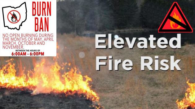
SPECIAL WEATHER STATEMENT FOR ATHENS COUNTY, SUNDAY 3/14/2021 – The combination of low relative humidity, above normal temperatures, and gusty winds will create an elevated risk for wildfires this afternoon and evening.

Open burning of any type is considered extremely dangerous at this time. Be careful of heat and sparks while operating any equipment and avoid smoking in wildland areas.

Ohio law prohibits burning in the spring from 6AM to 6PM, March 1st through May 31st.

Athens Co elevated risk of wildfires this afternoon and early evening, Wed, 03/10/21, open burning extremely dangerous

Athens County elevated risk of wildfires this afternoon and early evening, Wednesday, 03/10/2021.

The combination of low relative humidity, above normal temperatures, and gusty winds will create an elevated risk for wildfires this afternoon and evening.

Open burning of any type is considered extremely dangerous at this time. Be careful of heat and sparks while operating any equipment and avoid smoking in wildland areas.

Ohio State Law prohibits burning in the spring from 6 AM to 6 PM March 1st through May 31st.

ATHENS CO FLOOD WARNING UNTIL 5PM, SUN, 2/28/2021, FLOODING IS ON GOING, TURN AROUND, DON’T DROWN!

The National Weather Service in Charleston has issued a FLOOD WARNING for Athens County Until 5:00 PM, Sunday, 2/28/2021.

At 11:24 AM, Doppler radar indicated heavy rain occurring across the area. Flooding is ongoing or expected to begin shortly in the warned area. Between 1.5 and 2.5 inches of rain have fallen and water levels will rise throughout this afternoon.

Some locations that will experience flooding include Athens, Nelsonville, Glouster, and Albany.

PRECAUTIONARY/PREPAREDNESS ACTIONS:
Turn around, don`t drown when encountering flooded roads. Most flood deaths occur in vehicles.

Stay away or be swept away. River banks and culverts can become unstable and unsafe.

ATHENS CO WINTER WEATHER ADVISORY 7PM, WED, 2/17/21 TO 5AM, FRI, 2/19/21, 1 TO 4 INCHES OF SNOW EXPECTED

The National Weather Service has issued a WINTER WEATHER ADVISORY for Athens County in effect from 7:00PM, Wednesday, 2/17/2021 until 5:00AM, Friday, 2/19/2021.

  • WHAT – Snow expected. Total snow accumulations of 1 to 4 inches.
  • WHERE – Portions of southeast Ohio and northern West Virginia.
  • WHEN – From 7:00PM, Wednesday, 2/17/2021 until 5:00AM, Friday, 2/19/2021.
  • IMPACTS – Plan on slippery road conditions. The hazardous conditions could impact the morning or evening commute.

PRECAUTIONARY/PREPAREDNESS ACTIONS:
Slow down and use caution while traveling.

Additional information can be found at https://www.weather.gov/rlx as well as on our Facebook and Twitter pages.

ATHENS CO WINTER STORM WATCH 7PM, WED, 2/17/21 UNTIL 7AM, FRI, 2/19/21, HEAVY SNOW OF 4 INCHES POSSIBLE, WATCH FORECASTS

The National Weather Service has issued a WINTER STORM WATCH from 7:00PM, Wednesday, 2/17/2021 until 7:00AM, Friday, 2/19/2021.

  • WHAT – Heavy snow possible. Total snow accumulations of over 4 inches possible.
  • WHERE – Portions of southeast Ohio.
  • WHEN – From 7:00PM, Wednesday, 2/17/2021 until 7:00AM, Friday, 2/19/2021.
  • IMPACTS – Travel could be very difficult. The hazardous conditions could impact the morning or evening commute.
  • ADDITIONAL DETAILS – Two rounds of wintry precipitation are expected. The first is forecast to occur Wednesday night into Thursday morning. The second is forecast to occur Thursday night.

PRECAUTIONARY/PREPAREDNESS ACTIONS:
Monitor the latest forecasts for updates on this situation.