The City of Nelsonville has closed the Eastern side of the Public Square from Stuarts Opera House to the Rhapsody Restaurant to all vehicle and pedestrian foot traffic until further notice. The area is not safe due to the buildings being damaged by fire. Please avoid this area.
April 2015
Fire Damages Four Historic Nelsonville Public Square Buildings
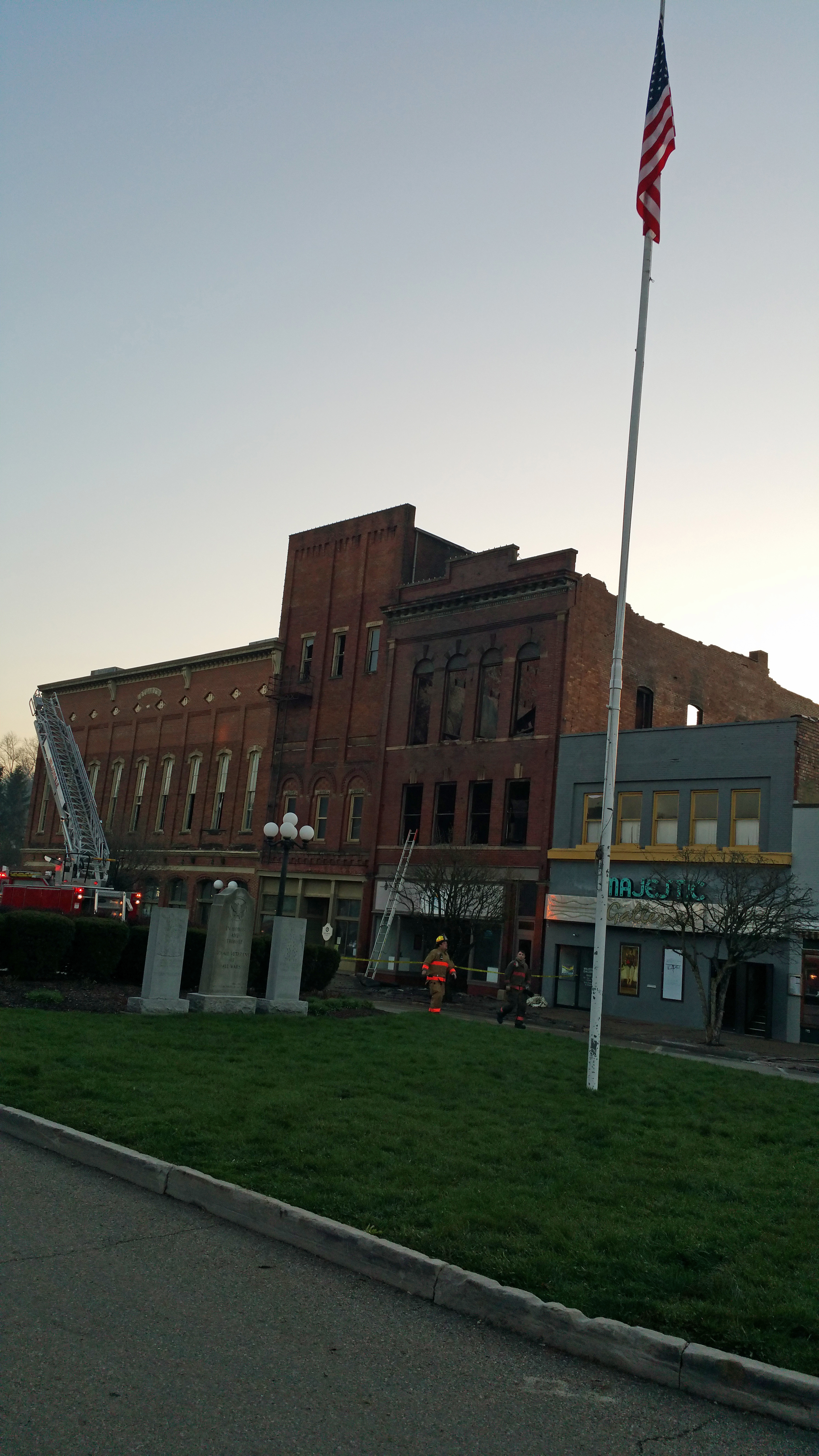
The Nelsonville Division of Fire was alerted for a blown electrical transformer behind 29 ½ East Columbus Street at 10:20 PM on Saturday, April 11th. On arrival in the area firefighters discovered smoke coming from the roof of 30 Public Square, which houses the Hocking Galleries. Fire fighters initiated an aggressive interior fire attack but were forced to retreat from the interior of the building by severe fire conditions. Firefighters from Nelsonville, York Township, The Plains, Logan and Athens were able to contain the fire by 3:00 AM, Sunday, April 12th. No civilians or emergency personnel were injured during fire.
Four Public Square buildings suffered damage from the fire.
*20 Public Square
Owner – L HeureuxEUREUX LTD, Athens, Ohio, Built 1914
Business – Majestic Art Galleries
Smoke and Water Damage
*30 Public Square
Owner – Hocking Valley Museum of Theatrical History Inc., Built 1879
Business – Hocking Art Galleries
Severe Fire and Water Damage
*34 Public Square
Owner – Hocking Valley Museum of Theatrical History Inc., Built 1879
Business – McFadden Insurance Services
Fire, Water and Smoke Damage
*36, 46, 52 Public Square
Owner – Hocking Valley Museum of Theatrical History Inc., Built 1879
Business – Stuarts Opera House
Smoke and Water Damage
No damage estimate is available at this time. The cause of the fire is under investigation at this time. Firefighters remain on the scene extinguishing hot spots.
More information will be released as it becomes available.
Firefighters contain fire on Nelsonville Public Square
Firefighters from five different Fire Departments have been able to contain a fire that was discovered shortly before 11:00 PM Saturday evening. No cause has been determined at this time. Firefighters are continuing to put water on hot spots. There have been no Injuries.
More information will be released as it becomes available.
Fire Damages Buildings on Historic Nelsonville Public Square
The Nelsonville Division of Fire is currently battling a fire located on the historic Nelsonville Public Square. Shortly before 11:00 PM Saturday night firefighters were called to the area of the 28 East Columbus Street for a blown electrical transformer. While on scene firefighters noticed smoke coming from 30 Public Square. Firefighters from Nelsonville, York Township, The Plains, Logan and Athens are currently working on fighting the fire at 30 Public Square and 34 Public Square. No cause for the fire has been determined at this time. All buildings on the East side of the Public Square have been evacuated. No Injuries have been reported at this time.
More information will be released as it becomes available.
Athens County Flooding Road Closures as of 3:00 PM, Friday, April 10, 2015, follow link
Athens County Road Clousres
April 10, 2015 – 3:00 PM
ROAD NAME LOCATION
CR 1 – Carbondale Road
CR 4 – Glenn Ebon Road Between SR 691 and US Route 33
CR 18 – Frost Road
CR 24 – Both South Canaan Road and Harmony Road
CR 33B – Diamond Brick Road
CR 57 – Rodehaver Road
CR 58 – Frost Road
CR 109 – Beebe Road
Ohio Department of Transportation Closures From http://www.ohgo.com
SR 56 Between Vinton County line and Athens City Corporation
SR 144 Between US 50 and SR 329
SR 329 Between US 50 and SR 144
SR 356 Between SR 681 and SR 356
ATHENS CO SEVERE THUNDER STORM WATCH UNTIL 10AM, FRIDAY, 4/10. WATCH FO RAPIDLY CHANGING WEATHER CONDITIONS!
A SEVERE THUNDER STORM WATCH HAS BEEN ISSUED FOR ATHENS COUNTY UNTIL 10AM, FRIDAY, 4/10.
REMEMBER, A SEVERE THUNDERSTORM WATCH MEANS CONDITIONS ARE FAVORABLE FOR SEVERE THUNDERSTORMS IN AND CLOSE TO THE WATCH AREA. PERSONS IN THESE AREAS SHOULD BE ON THE LOOKOUT FOR THREATENING WEATHER CONDITIONS AND LISTEN FOR LATER STATEMENTS AND POSSIBLE WARNINGS. SEVERE THUNDERSTORMS CAN AND OCCASIONALLY DO PRODUCE TORNADOES.
STAY TUNED TO NOAA WEATHER RADIO, LOCAL TV, RADIO OR YOUR CABLE TELEVISION PROVIDER FOR LATER STATEMENTS AND POSSIBLE WARNINGS.
Athens County Flooding Road Closures as of 11:00 AM, Thursday, April 9, 2015 follow link
Athens County Flooding Road Closures as of 11:00 AM, Thursday, April 9, 2015.
CR 4 – Glenn Ebon Road Between SR 691 and US Route 33
CR 18 – Frost Road
CR 33B – Diamond Brick Road
CR 58 – Frost Road
CR 109 – Beebe Road
Ohio Department of Transportation Closures From http://www.ohgo.com
SR 56 Between Vinton County line and Carbondale Road
SR 56 Between SR 356 and Grass Run Road
SR 329 Between Tick Ridge Road and Marietta Run Road
US 33 Restricted Both directions, near Dorr Run Exit, #182
FLASH FLOOD WARNING FOR ATHENS CO UNTIL 2:30AM THU, 4/9, SEEK HIGH GROUND IF THREATENED, AVOID FLOODED ROADWAYS!
THE NATIONAL WEATHER SERVICE HAS ISSUED A FLASH FLOOD WARNING FOR ATHENS COUNTY UNTIL 2:30AM THURSDAY, 4/9.
NATIONAL WEATHER SERVICE DOPPLER RADAR INDICATED VERY HEAVY RAIN FROM REPEATED THUNDERSTORMS OVER THE WARNED AREA. THUNDERSTORMS ARE EXPECTED TO CONTINUE OVER THE NEXT COUPLE OF HOURS ACROSS THE WARNED AREA, WITH AN ADDITIONAL INCH OF RAIN POSSIBLE.
PRECAUTIONARY/PREPAREDNESS ACTIONS: EXCESSIVE RUNOFF FROM HEAVY RAINFALL WILL CAUSE FLOODING OF SMALL CREEKS AND STREAMS, HIGHWAYS AND UNDERPASSES. ADDITIONALLY, COUNTRY ROADS AND FARMLANDS ALONG THE BANKS OF CREEKS, STREAMS AND OTHER LOW LYING AREAS ARE SUBJECT TO FLOODING.
DO NOT DRIVE YOUR VEHICLE INTO AREAS WHERE THE WATER COVERS THE ROADWAY. THE WATER DEPTH MAY BE TOO GREAT TO ALLOW YOUR CAR TO CROSS SAFELY. MOVE TO HIGHER GROUND.
PLEASE REPORT HIGH WATER TO THE NATIONAL WEATHER SERVICE BY CALLING TOLL FREE 1-800-401-9535, WHEN YOU CAN DO SO SAFELY.
YOU MAY ALSO REPORT HIGH WATER BY POSTING YOUR REPORT TO THE CHARLESTON WEST VIRGINIA NATIONAL WEATHER SERVICE FACEBOOK PAGE OR BY USING THE TWITTER HASHTAG, #NWSRLX.
ATHENS CO FLOOD WATCH 11PM, THU, 4/2 UNTIL 2AM SAT, 4/4, WATCH FOR CHANING WEATHER CONDITIONS!
THE NATIONAL WEATHER SERVICE HAS ISSUED A FLOOD WATCH FOR ATHENS COUNTY FROM 11PM THURSDAY, 4/2 UNTIL 2AM SATURDAY, 4/4.
WHAT: MULTIPLE ROUNDS OF RAIN
HOW MUCH: TOTAL ACCUMULATIONS COULD BE AROUND 2 INCHES
IMPACT: SMALL STREAM FLOODING IS POSSIBLE. MAINSTEM RIVERS WILL SEE SIGNIFICANT RISES.
PRECAUTIONARY/PREPAREDNESS ACTIONS: A FLOOD WATCH MEANS THERE IS A POTENTIAL FOR FLOODING BASED ON CURRENT FORECASTS.
YOU SHOULD MONITOR LATER FORECASTS AND BE ALERT FOR POSSIBLE FLOOD WARNINGS. THOSE LIVING IN AREAS PRONE TO FLOODING SHOULD BE PREPARED TO TAKE ACTION SHOULD FLOODING DEVELOP.


