
12/11/2024, 10:15 PM – Athens County is under a LEVEL 1 SNOW EMERGENCY. Roadways are hazardous with blowing and drifting snow. Roads may also be icy. Motorists are urged to drive very cautiously.

12/11/2024, 10:15 PM – Athens County is under a LEVEL 1 SNOW EMERGENCY. Roadways are hazardous with blowing and drifting snow. Roads may also be icy. Motorists are urged to drive very cautiously.

The National Weather Service has issued a WIND ADVISORY for Athens County in effect until 7AM, Thursday, December 5, 2024.
-WHAT…West winds 15 to 20 mph with gusts up to 45 mph expected.
-WHERE…Portions of northeast Kentucky, southeast Ohio, southwest Virginia, and central, northeast, northern, southeast, southern, and western West Virginia.
-WHEN…Until 7AM, Thursday, December 5, 2024.
-IMPACTS…Gusty winds will blow around unsecured objects. Tree limbs could be blown down and a few power outages may result.
-ADDITIONAL DETAILS…The strongest winds will occur as an arctic front passes quickly across the area during the overnight hours.
PRECAUTIONARY/PREPAREDNESS ACTIONS…Winds this strong can make driving difficult, especially for high profile vehicles. Use extra caution.

11/30/2024, 9:28PM – The snow emergency for Athens County has been canceled. Please drive carefully some hazardous road conditions may still exist in remote areas of the county.
11/29/2024, 8:11 PM – Athens County is under a LEVEL 1 SNOW EMERGENCY. Roadways are hazardous with blowing and drifting snow. Roads may also be icy. Motorists are urged to drive very cautiously.
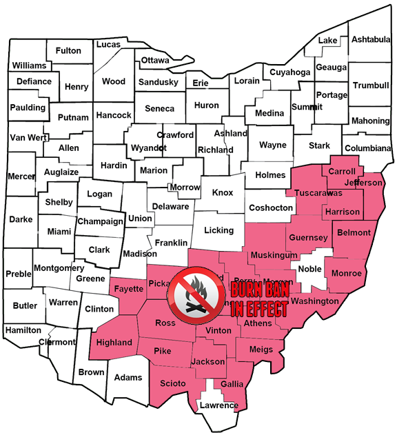
In response to extremely dry conditions in various areas of the state, Ohio Fire Marshal Kevin Reardon has ordered a regional Ban on Open Burning effective immediately. The ban impacts any county in Ohio identified by the National Oceanic and Atmospheric Administration (NOAA) or United States Department of Agriculture (USDA) as being in the “Extreme Drought” or “Exceptional Drought” categories as identified by the United States Drought Monitoring System.
The Burn on Open Burning ordered today, Sept. 6, 2024, includes the following Ohio counties: Athens, Belmont, Carroll, Fairfield, Fayette, Gallia, Guernsey, Harrison, Highland, Hocking, Jackson, Jefferson, Meigs, Monroe, Morgan, Muskingum, Perry, Pickaway, Pike, Ross, Scioto, Tuscarawas, Vinton, and Washington. Additional counties may be added upon designation of “Extreme Drought” or “Exceptional Drought” conditions issued by NOAA and/or the USDA within such counties or added by written directive of the State Fire Marshal.
Examples of outdoor activities prohibited by this order in the ban area include the following: lighting or maintaining an fire of any type at any location, smoking (including cigarettes or similar devices, and as part of a cooking process), non-electric cooking (regardless of fuel source), using or discharging any type of fireworks, throwing down/discarding lighted or smoldering material (including matches or cigarettes), campfires, bonfires, live fire training events, flame effect(s) based displays or exhibitions (including sky lanterns and cold spark machines), and using spark causing devices for recreational purposes.
“Fire safety is a responsibility we all share,” said Ohio State Fire Marshal Kevin Reardon. “It’s critical that Ohioans understand and appreciate the significant risks associated with fires, especially during the current drought conditions. Together we can protect our communities and environment.”
The Ohio Department of Commerce’s Division of State Fire Marshal, Ohio Department of Natural Resources (ODNR) Division of Forestry, and the Wayne National Forest urge all Ohioans to take special precautions due to the dry weather, whether they are in a county impacted by the Ban on Open Burning or not.
“All Ohioans, particularly homeowners, farmers, and woodland owners, should be cautious during this dry period,” said ODNR Division of Forestry Fire Prevention Manager Aaron Kloss. “Most of the plant materials in Ohio that can fuel wildfires are currently dry and will stay this way until we have significant rainfall. Current dry weather patterns with warm temperatures, low humidities, and wind are increasing the risk of wildland fires in Ohio.”
Dry grasses, shrubs, dead leaves, and fallen pine needles are all examples of plant materials that can fuel wildfires. Even if rain is in the forecast, it will require an extended period of soaking rains to reduce the elevated threat of wildfires throughout the state. Spring and fall are the typical wildfire seasons in Ohio; however, the current weather situation and resulting wildfire fuel situation is not typical. Warm, dry windy days in the fall, combined with abundant dead leaves falling and herbaceous plants entering dormancy and drying out, typically create situations conducive to wildfire igniting and spreading.
“Familiar things like vehicle exhaust pipes or an unattended campfire could quickly ignite dry fuels,” said Wayne National Forest Supervisor Lee Stewart. “We’re asking the public to be careful with outdoor fires. If you’re outdoors this season, please be observant and report smoke or flames to emergency authorities right away. Our fire and law enforcement personnel are ready to serve and respond when needed.”
Residents can take measures to prevent accidental wildfires including, avoiding burning trash and debris, keeping grass trimmed, not discarding cigarettes and other smoking materials outside, postponing fireworks, and avoiding open cooking fires or campfires. Additionally, farmers should regularly check their equipment for any irregularities that can lead to a brush or crop field fire.
Anyone who sees any signs of wildfire should call their local fire department immediately to report it. Accurate and timely reporting of wildfire responses by Ohio fire departments is important for a rapid response to the incident.
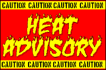
The National Weather Service has issued a HEAT ADVISORY for Athens County and surrounding areas until 8:00PM, Friday, August 30, 2024.
WHAT…Heat index values up to 101.
WHERE…Portions of northeast Kentucky, southeast Ohio, and southern West Virginia.
WHEN…Until 8:00PM, Friday, August 30, 2024.
IMPACTS…Hot temperatures and high humidity may cause heat illnesses.
PRECAUTIONARY/PREPAREDNESS ACTIONS… Drink plenty of fluids, stay in an air-conditioned room, stay out of the sun and check up on relatives and neighbors. Young children and pets should never be left unattended in vehicles under any circumstances.
The National Weather Service has issued a HEAT ADVISORY for Athens County and surrounding areas for Wednesday, August 28, 2024, from 12:00PM until 8:00PM.
WHAT…Heat index values up to 104 degrees expected.
WHERE…Portions of northeast Kentucky, southeast Ohio, and central and western West Virginia.
WHEN… Wednesday, August 28, 2024, from 12:00PM until 8:00PM.
IMPACTS…Hot temperatures and high humidity may cause heat illnesses.
PRECAUTIONARY/PREPAREDNESS ACTIONS… Drink plenty of fluids, stay in an air-conditioned room, stay out of the sun, and check up on relatives and neighbors. Young children and pets should never be left unattended in vehicles under any circumstances.
The National Weather Service has issued a Heat Advisory for Athens County in effect Monday, July 15, 2024, from 2:00 PM, until 8:00 PM.
WHAT…Heat index values up to 100 expected.
WHERE…Portions of northeast Kentucky, southeast Ohio, and central, northern, and southern West Virginia.
WHEN… Monday, July 15, 2024, from 2:00 PM, until 8:00 PM.
IMPACTS…Hot temperatures and high humidity may cause heat illnesses.
PRECAUTIONARY/PREPAREDNESS ACTIONS… Drink plenty of fluids, stay in an air-conditioned room, stay out of the sun, and check up on relatives and neighbors. Young children and pets should never be left unattended in vehicles under any circumstances.
The National Weather Service has issued a Heat Advisory for Athens County from 12 Noon until 8:00PM, Wednesday, July 3, 2024.
WHAT…Heat index values around 100 expected.
WHERE…Portions of northeast Kentucky, southeast Ohio, and central, northern, southern, and western West Virginia.
WHEN…From 12 Noon until 8:00PM, Wednesday July 3, 2024.
IMPACTS…Hot temperatures and high humidity may cause heat illnesses.
PRECAUTIONARY/PREPAREDNESS ACTIONS… Drink plenty of fluids, stay in an air-conditioned room, stay out of the sun, and check up on relatives and neighbors. Young children and pets should never be left unattended in vehicles under any circumstances. Anyone overcome by heat should be moved to a cool and shaded location. Heat stroke is an emergency! Call 9-1-1.

The National Weather Service has issued a Severe Thunderstorm Watch for Athens County until 10:00 PM, Wednesday, June 26, 2024.
Remember, a Severe Thunderstorm Watch means conditions are favorable for Severe Thunderstorms in and close to the watch area. Persons in these areas should be on the lookout for threatening weather conditions and listen for later statements and possible warnings. Severe Thunderstorms can and occasionally do produce Tornadoes.
Stay tuned to NOAA Weather Radio, local TV, radio or your cable television provider for later statements and possible warnings.
